
Irma appears to be tracking west of forecasts
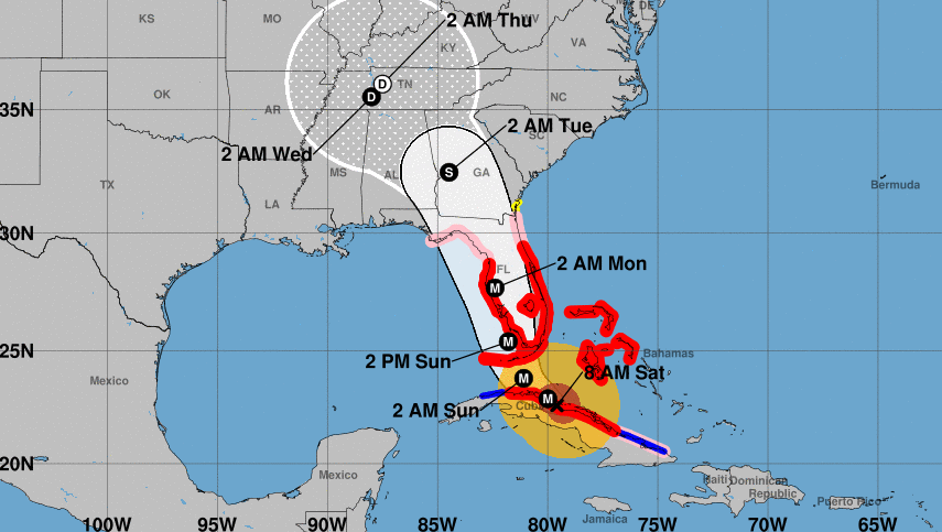
At this time yesterday, Irma was expected to have tracked north of Cuba but instead it leveled out and continued on a westwardly path. Unfortunately, that was a worst-case scenario for parts of Cuba, where they are waking up to total disaster.
Because the storm made landfall in Cuba, it's weakened to 130 mph from 155 mph yesterday, according to the forecast just released from the NHC. However, its expected to reintensify when it moves back over open water.
The westward path defied most forecasters but it's great news for the east coast of Florida, including Miami. That area is now likely to be spared the worst of the wind, however the storm surge still looks dire.
Forecasters continue to expect a turn northward but it's now highly unlikely that the storm goes up the spine of Florida. Instead, it's forecast to track along the east coast and make landfall somewhere between Naples and Tampa. It's increasingly possible, however, that the eye of the hurricane will pass to the east of the bulk of the state.
Here's what the NHC says:
"A northwest motion is expected to begin later today with a turn toward the north-northwest tonight or on Sunday. On the forecast track, the core of Irma will continue to move near or over the north coast of Cuba this morning, and will reach the Florida Keys Sunday morning. The hurricane is expected to be near the southwest coast of Florida Sunday afternoon."

